Author I Professor Dr. Md. Ataur Rahman I Department of Water Resources Engineering
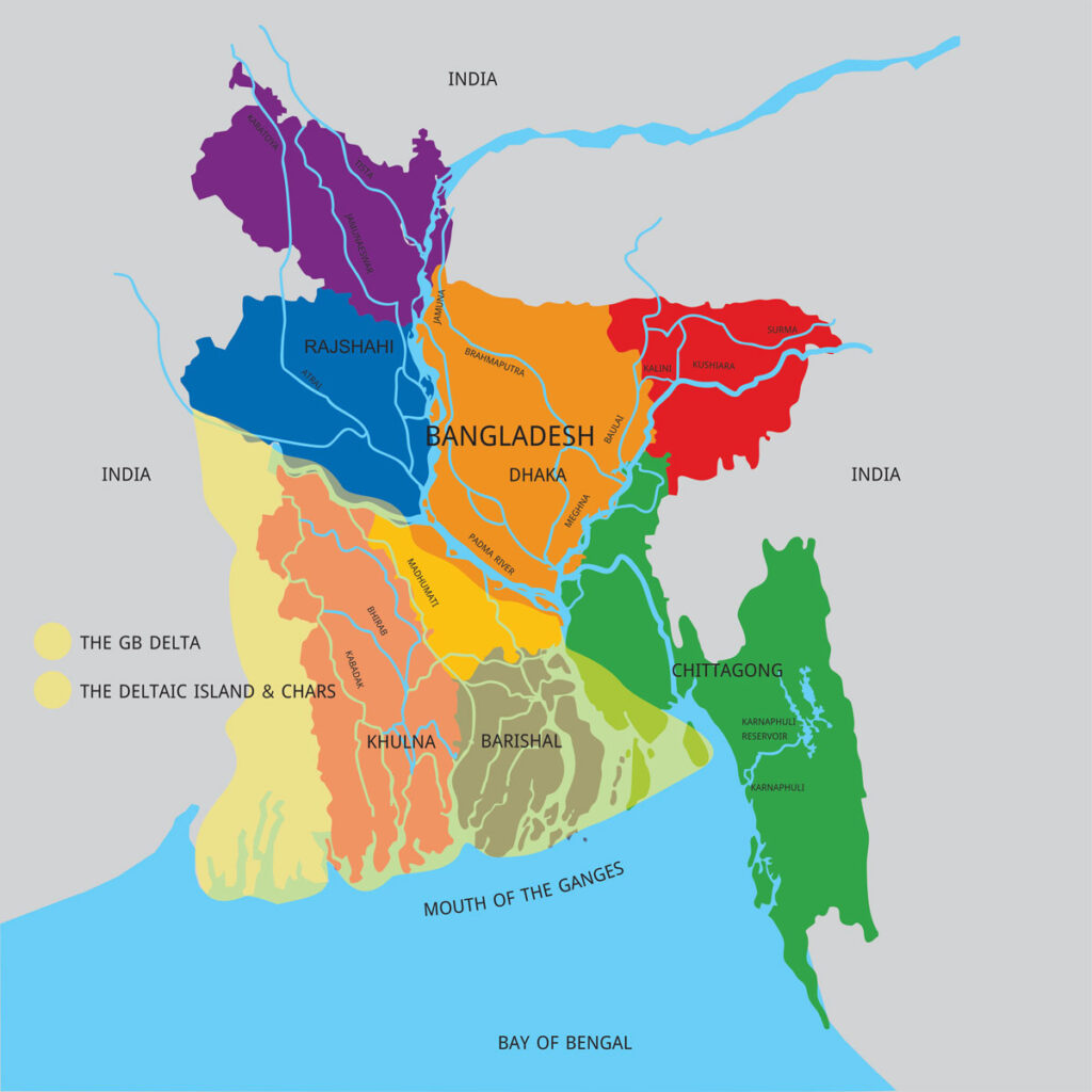
The land surrounded by water on all sides is called an island. If the island formed by silting in the estuary of the river on the seacoast is shaped by the dimensionless Bengali letter ‘B’, then it is called a delta. Again, the Greek symbol (delta) is called delta because it looks like the dimensionless Bengali letter ‘B’. Before knowing about Bangladesh Delta Plan 2100, we need to know why Bangladesh is called Delta. The Ganges and the Brahmaputra, two major rivers that originate in the Himalayas and carry large bodies of water and alluvial soil, have created vast floodplains that form a vast floodplain before falling into the Bay of Bengal and covering parts of the Indian state of West Bengal. This region surrounded by numerous rivers is called Bengal Delta or Bengal Delta because of the ‘B’ shape. The Bengal Delta covers the vast area from the Hooghly River in West Bengal in the west to the Meghna River in Bangladesh in the east, most of which is in Bangladesh. It is the largest riverine delta in the world and is one of the most fertile regions in the world, so it is also called the Green Delta. Now let’s talk about Bangladesh Delta Plan 2100. Formed by alluvial soil in the low-lying areas of the Himalayan basin and surrounded by numerous rivers, Bangladesh is one of the most fertile regions on the one hand, and on the other hand, due to its geographical location, it is a big challenge to deal with various natural challenges. In addition to the natural challenges of excessive rainfall, flood, drought, river erosion, tidal surge, siltation of riverbeds, salinity, it is very difficult for Bangladesh to deal with the effects of climate change. The natural adversities of Bangladesh are very similar to the natural adversities of the Netherlands, a European country located on the North Sea coast of the Atlantic Ocean. In 2011, the Dutch government prepared a plan for the Netherlands to tackle floods, provide clean water and combat the harmful effects of climate change. According to the direction of that plan, they have been taking various projects. In 2018, the Government of Bangladesh has formulated a Centenary Plan named “Bangladesh Delta Plan 2100” as a long-term strategy for flood, river erosion, river management, water supply, flood control and drainage management in Bangladesh. Six goals have been set in the Delta Plan: flood, river erosion, river management, water supply in urban and rural areas, waste management, flood control and drainage. In the meantime, the ‘Delta Governance Council’, formed under the leadership of the Prime Minister, has started working to implement this plan.

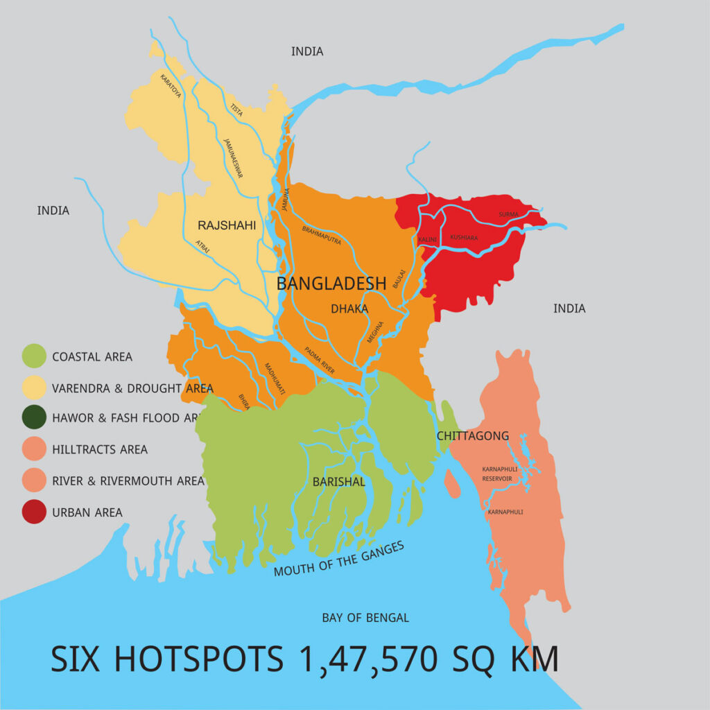
The members of the Delta Governance Council are the Planning Minister, Agriculture Minister, Finance Minister, Local Government Minister, Food Minister, Land Minister, Environment, Forest and Climate Change Minister, Fisheries and Livestock Minister or State Minister, Shipping Minister or State Minister, Water Resources Minister or State Minister, Disaster Management and Relief Minister or State Minister and State Minister for Planning. A member of the General Economics Department of the Planning Commission has been made the member secretary of the council. In the first phase of this master plan, 80 projects have been taken for implementation by 2030. Of these, 65 are physical infrastructure projects and 15 are institutional capacity, efficiency and research projects. The total cost is estimated at $37 billion. The ministries are sometimes working alone and sometimes jointly to implement the plan. The Centennial Delta Plan focuses on finding strategies to protect against floods and climate change. And then there’s water security. Apart from this, sustainable river-zones, wetland conservation, proper management of transboundary river water have also been mentioned in the delta plan. The Delta Plan identifies six hotspots (Image-2) as challenges, which are mainly areas with common problems due to water and climate. These are the coastal region of 27,738 square kilometers, the Barind and drought prone areas of 22,848 square kilometers, the haor and flash flood prone areas of 16,574 square kilometers, the Chittagong Hill Tracts region of 13,295 square kilometers, the river and estuarine areas of 35,204 square kilometers and the urban area of 19,823 square kilometers. Hotspot-based problems have been highlighted separately in the plan. The problems include (1) cyclone, flood, tidal surge, salinity, waterlogging, erosion in rivers and coastal areas, depleting ground water level, (2) availability of fresh water, depleting ground water level in the Barind and drought-prone areas, inadequate sanitation, environmental degradation, (3) in haor and flash flood-prone areas – availability of fresh water, flash or seasonal floods, waterlogging and inadequate drainage, Inadequate water and sanitation, (4) Scarcity of fresh water, inadequate sanitation and conservation of decreasing biodiversity in the Chittagong Hill Tracts, (5) Floods, environmental degradation, water pollution, silt management and navigation, river bed changes, erosion and emergence of new chars, and (6) in urban areas – inadequate sanitation, waterlogging, freshwater sufficiency and waste management. In the master plan, environmental degradation has been identified as a common problem in each hotspot. The vision of the Delta Plan is to build a safe, climate change tolerant and prosperous delta. The mission of this master plan is to ensure long-term water and food security, economic growth and environmental sustainability by adopting strong, coordinated and time-changing operational strategies and equitable water management, tackling natural disasters, climate change shocks and other delta-related problems. The Delta Plan has set three higher level national goals, and six specific targets related to the delta. The Delta Plan has set three higher level national goals, and six specific targets related to the delta. Delta-related goals will contribute to the achievement of higher-level goals. The high-level goals are to end extreme poverty by 2030, achieve upper-middle-income country status by 2030, and achieve the status of a prosperous country by 2041. The six specific goals related to the delta are: ensuring protection from floods and climate change-related disasters, increasing water security and greater efficiency in water use, building integrated and sustainable river areas and estuarine systems, ensuring the conservation and proper use of wetlands and ecosystems, building effective institutions and equitable governance for the proper management of transboundary and transboundary water resources, and ensuring the best integrated use of land and water resources. Bangladesh Delta Plan 2100 is a very timely plan to build a developed Bangladesh by facing the challenges of natural adversity and climate change. Planning, designing and constructing all the technical projects to be undertaken to implement this plan is as expensive as it is financially expensive as well as technically challenging. Accepting this challenge, the role of water resources engineers is very important in building a prosperous Bangladesh through the implementation of the Delta Plan. Dhaka, 02 Dec 2024.

References: Bangladesh Delta Plan 2100: 21st Century Bangladesh, GED, Bangladesh Planning Commission.

মন্তব্য করুন
মন্তব্য করার জন্য আপনাকে অবশ্যই লগইন করতে হবে।